Ecomorphodynamics of Intertidal Ecosystems in
Modified Estuaries
 'Ecomorphodynamics'
refers to the study of the interaction and adjustment of topography, vegetation,
fluid and hydrodynamic processes, morphologies and sequence of change dynamics
involving the movement of sediment. These feedbacks are clearly evident within
the vast intertidal ecosystems located in macrotidal systems such as the Bay of
Fundy. Salt marshes and mudflats represent delicately balanced systems between
hydrodynamic forces and ecological, sedimentological and morphological
responses.
A key to survival for many of these
coastal ecosystems in face of climate change is to maintain this delicate
balance. Changes in marsh or mudflat surface elevation within the tidal frame
or changes in edge morphology will in turn induce changes in tidal prism,
hydrodynamic forces, vegetation community structure, rates of sedimentation and
dissipation (marsh platform) or amplification (cliff) of wave energy. The rate
of these changes can be significantly influenced by human development such as
the construction of tidal barriers or installation of shore protection.
'Ecomorphodynamics'
refers to the study of the interaction and adjustment of topography, vegetation,
fluid and hydrodynamic processes, morphologies and sequence of change dynamics
involving the movement of sediment. These feedbacks are clearly evident within
the vast intertidal ecosystems located in macrotidal systems such as the Bay of
Fundy. Salt marshes and mudflats represent delicately balanced systems between
hydrodynamic forces and ecological, sedimentological and morphological
responses.
A key to survival for many of these
coastal ecosystems in face of climate change is to maintain this delicate
balance. Changes in marsh or mudflat surface elevation within the tidal frame
or changes in edge morphology will in turn induce changes in tidal prism,
hydrodynamic forces, vegetation community structure, rates of sedimentation and
dissipation (marsh platform) or amplification (cliff) of wave energy. The rate
of these changes can be significantly influenced by human development such as
the construction of tidal barriers or installation of shore protection.
The purpose of
this research program is to examine the spatial and temporal changes in
intertidal habitats
in macrotidal environments such as the Bay of Fundy and isolate the
relative significance of factors controlling these changes. It involves the
integration of meso-scale (decadal/basin wide) quantification of geomorphic
changes in the intertidal zone using ArcGIS and high resolution digital
elevation models with micro-scale (seasonal to tidal
cycle/marsh level) investigations of sedimentary processes within salt marshes
and mudflats of this region. 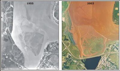
These research projects will help to develop an
understanding of the mechanisms controlling the stability and resilience of
mudflat and salt marsh systems in the Bay of Fundy, identifying geomorphic
triggers between erosive and progradational states and overall response to the
effects of climate change.
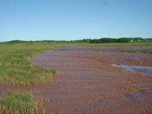
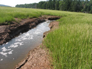
Development of marsh/mudfalt system downstream
of the Windsor causeway (van Proosdij & Townsend, 2006)
Of particular interest is the response or
resiliency of intertidal ecosystems to anthropogenic activities such as dyke and
causeway construction or shore protection and the potential responses of the
ecosystem to removing these tidal barrier structures or modifying the tidal
energy within the area (e.g. tidal power).
Collaborators:
-
Nova Scotia Department of Agriculture, Resource Stewardship
Division, Land Protection Section
-
Department of Fisheries and
Oceans, Bedford Institute of Oceanography
-
Nova Scotia Department of Transportation and
Infrastructure Renewal
-
Acadia Center for Estuarine Research
Past &
Present Students:
-
Greg Baker, Sarah
Townsend, Jillian Bambrick, Amanda Pike, Erinn O'Toole, Peter Horne, Kelly
Mazerolle, Casey O'Laughlin
Funding
Sources:
Selected Publications:
-
van Proosdij, D.; Milligan, T.; Budgen, G. and
C. Butler. 2009. A Tale of Two Estuaries: Differential Morphodynamic
Response of the Intertidal Zone to Causeway Construction. Journal
of Coastal Research SI 56:772-776. ISBN 0749-0258.
-
van
Proosdij, D. and G. Baker. 2008.
Intertidal Morphodynamics of the Avon River
Estuary. Final report prepared for the Nova Scotia Department of Transportation
186 pp.
-
van Proosdij, D; Bambrick, J.
and G. Baker. 2007.
Spatial and Temporal Variations in the Intertidal
Geomorphology of the Avon River Estuary. Final report
prepared for the Nova Scotia Department of Transportation 82 pp.
-
van Proosdij, D.
and S., Townsend. 2006.
Spatial and Temporal Patterns of Salt Marsh
Colonization Following Causeway Construction in the Bay of Fundy.
Journal of Coastal Research, SI 39 (Proceedings of the 8th International
Coastal Symposium):1858-1862, Itajai, SC - Brazil, 2004 ISSN 0749-0208
-
Daborn, G.R.; Brylinsky, M. and
D. van Proosdij. 2003.
Ecological Studies of the Windsor Causeway and Pesaquid
Lake, 2002. Final report prepared for Nova Scotia Department of Transportation
Contract # 02-00026. Acadia Centre for Estuarine Research Publication No. 69.
111 pp.
Hydrodynamics and Sedimentary Processes of Intertidal
Ecosystems
The purpose of this research is
to examine the temporal and spatial variations in hydrodynamics and sedimentary
processes of intertidal ecosystems with a particular focus on muddy macrotidal
systems. The new (2008) Intertidal Coastal Sediment Transport Research Unit (In_CoaST)
at Saint Mary's University will play an integral role for this research.
The research
will examine the interactions and feedbacks that occur between topography, biota
(e.g. vegetation and invertebrates), hydrodynamic (e.g. waves and currents) and
sedimentary (e.g. suspended sediment concentration, deposition, erosion)
processes and the resultant adjustment of intertidal morphology at a range of
spatial and temporal scales. Of particular interest is the response of
intertidal environments to changes in forcing functions (e.g. wind, waves,
tides, currents, sediment, vegetation, topography) and how anthropogenic
activities impact this response.
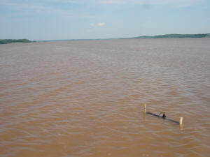
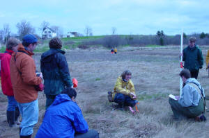
Data collection at low and mid spring tide on
the Avon River, Bay of Fundy (photo by A. Silver,2008)
Additional research is being
undertaken to examine the role of ice and winter meteorological conditions on
sediment transport processes and dispersal of vegetation.
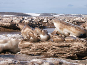
Ice blocks laden with sediment on Windsor
marsh, Feb 2007
Collaborators:
-
Mount Alison Coastal Wetlands Institute
-
Department of Geography, University of Guelph
-
Department of Fisheries and
Oceans, Bedford Institute of Oceanography
-
Natural Sciences and Engineering Research
Council (NSERC)
Past &
Present Students:
Funding
Sources:
-
Natural Sciences and Engineering
Research Council (NSERC)
Selected Publications:
-
O'Laughlin, C. and D. van Proosdij. 2009. Comparison of Vertical and
Temporal Variations in Hydrodynamics on Macro-tidal Mudflat and Salt Marsh
Surfaces in the Bay of Fundy. Proceedings of the 8th Bay of Fundy
Ecosystem Partnership Science Workshop, Wolfville, NS. 10 pp.
-
Silver, A. and D. van Proosdij. 2009. The Influence of Vegetation on
Sedimentary Processes in a Macro-tidal Salt Marsh. Proceedings of the
8th Bay of Fundy Ecosystem Partnership Science Workshop, Wolfville, NS. 10
pp.
-
van Proosdij, D.; Davidson-Arnott, R.G.D.
and J. Ollerhead, J. 2006. Controls on the spatial patterns of sediment
deposition across a macro tidal salt marsh over single tidal cycles.
Estuarine, Coastal and Shelf Science 69(1-2):64-86.
-
van Proosdij, D.; Ollerhead, J. and R.G.D.
Davidson-Arnott. 2006. Seasonal and Annual Variations in the Sediment Mass
Balance of a Macro-tidal Salt Marsh. Marine Geology 225: 103-127.
- Davidson-Arnott, R.G.D.; van Proosdij, D.;
Schostak, L. and J. Ollerhead. 2002. Hydrodynamics and Sedimentation in
Saltmarshes: Examples from a Macro-tidal Marsh, Bay of Fundy. In Gares, P.
(editor), Coastal Processes and Dynamics, Proceedings of the 1998 Binghampton
Symposium in Geomorphology, Geomorphology 48: 209-231.
- van Proosdij, D.; Davidson-Arnott, R.G.D.
and J. Ollerhead. 2000. Controls on Suspended Sediment Deposition over
Single Tidal Cycles in a Macro-tidal Saltmarsh, Bay of Fundy. In Pye,K. and
Allen, J.R.L. (eds). Coastal and Estuarine Environments: Sedimentology,
Geomorphology and Geoarchaeology. Geological Society, London, Special
Publications, 175:43-57.
For centuries,
human activities have reduced
the amount of salt marsh and free-flowing tidal river habitats in many areas
around the world. Conservative estimates for the Bay of Fundy put the loss of
salt marsh habitat between 80 to 85% mostly associated with dyking and
conversion to agricultural land. Although these activities are of historical
and social significance, it is now recognized that the significant loss of
habitat, species and primary productivity that has resulted from the
construction of dikes, modern tidal barriers (causeways) and coastal development
has had significant ecological implications, which are preventable and
repairable if tidal hydrology is appropriately restored.
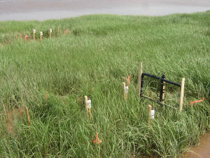
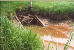
One year post dyke
breaching at Walton Creek restoration site, June 2007 (photo by CBWES Inc.)
Salt marsh ecosystem function
may be restored passively when a dike is breached during a storm with little to
no human interference or through active means by planned removal or modification
of a barrier to restore tidal flow. Examination of passive restoration sites
can provide long term records about vegetation and geomorphic recovery however
provide limited information about driving and/or limiting variables within the
first few years after the breach event that may influence the ultimate recovery
of the system. In addition, the European experience has shown that salt marsh
re-establishment is not inevitable at all sites following a breach. Properly
monitored restoration projects can sometimes provide additional information on
constraints that may have caused a restoration project to proceed along successional pathways not initially anticipated.
 My students and I work closely
with CB Wetlands and Environmental Specialists Inc
(CBWES) to examine the vegetative,
sedimentary, nekton and hydrologic conditions pre-restoration and the initial
five years post-restoration at salt marsh sites across the province both on the
Fundy and Atlantic coasts. Additional areas of research include tidal
channel hydraulics and wetland design and biogeographical processes (e.g.
vegetative community interactions, dispersal mechanisms) within these systems. Opportunities for
NSERC industrial internships with CBWES are available at the undergraduate and graduate level.
My students and I work closely
with CB Wetlands and Environmental Specialists Inc
(CBWES) to examine the vegetative,
sedimentary, nekton and hydrologic conditions pre-restoration and the initial
five years post-restoration at salt marsh sites across the province both on the
Fundy and Atlantic coasts. Additional areas of research include tidal
channel hydraulics and wetland design and biogeographical processes (e.g.
vegetative community interactions, dispersal mechanisms) within these systems. Opportunities for
NSERC industrial internships with CBWES are available at the undergraduate and graduate level.
These data will contribute to
the development of long term data sets of pre-restoration, post-restoration, and
reference marsh conditions to determine if a marsh is proceeding as expected and
to help with models that are aimed at predicting the response of marshes to
tidal restoration at the upper end of the tidal spectrum. In addition, these
results can provide insight into the ecological interrelationships between
biotic and abiotic variables and contribute to the development of a set of
reference marsh conditions for future restoration projects in the Bay of Fundy
and Atlantic coastal areas.
Collaborators:
-
CB
Wetlands and Environmental Specialists
-
Dr.
Jeremy Lundholm, Department of Biology, Saint Mary's University
-
Nova Scotia Department of Agriculture, Resource Stewardship
Division, Land Protection Section
-
Nova Scotia Department of Transportation and
Infrastructure Renewal
Past &
Present Students:
Funding
Sources:
-
Nova Scotia Department of
Transportation via CBWES
-
Saint Mary's University
Selected Publications:
- Bowron, T.M., N.C.
Neatt, J.M. Graham, J. Lundholm, and D. van Proosdij. 2008. Pre-construction
Monitoring (Baseline) of the St. Croix River High Salt Marsh and Floodplain
Wetland Restoration Project. Report prepared for Nova Scotia Department of
Transportation and Infrastructure Renewal.
CBWES Inc. Publication No. 10.
Halifax, NS. p. 69.
(link
to report) (restoration fact
sheet)
- Bowron, T.M., N.C. Neatt, J.M. Graham, J.
Lundholm, and D. van Proosdij. 2008. Post-Construction Monitoring (Year
1) of the Smith Gut Salt Marsh Restoration Project. Report prepared for Nova
Scotia Department of Transportation and Infrastructure Renewal.
CBWES Inc.
Publication No. 9. Halifax, NS. p. 118. (link
to report) (restoration fact
sheet)
- Bowron, T.M., N.C. Neatt, J.M. Graham, J.
Lundholm, and D. van Proosdij. 2008. Pre-Construction Monitoring of the
Lawrencetown Lake Salt Marsh Restoration Project (Version 2). Report Prepared
for Nova Scotia Department of Transportation and Infrastructure Renewal.
CBWES
Inc. Publication No. 8. Halifax, NS. p. 73.(link
to report) (restoration fact sheet)
- Bowron, T.M., N.C. Neatt, J.M. Graham, J.
Lundholm, and D. van Proosdij. 2008. Post-Construction Monitoring (Year
2) of the Walton River Salt Marsh Restoration Project. Report Prepared for Nova
Scotia Department of Transportation and Infrastructure Renewal.
CBWES Inc.
Publication No.7. Halifax, NS. p. 104
(link
to report) (restoration fact
sheet)
- Bowron, T.M., N.C. Neatt, J.M. Graham, J. Lundholm,
and D. van Proosdij. 2008. Post-Restoration Monitoring (Year 2) of the
Cheverie Creek Salt Marsh Restoration Site. Report prepared for Nova Scotia
Department of Transportation and Infrastructure Renewal.
CBWES Inc. Publication
No. 6. Halifax, NS. p. 122.
(link
to report) (restoration fact
sheet)

Tidal Barrier GIS Database Development
 Over
the last century, the majority of rivers entering into the Bay of Fundy have
been highly modified through the construction of tidal barriers. The
construction of these barriers resulted in either partial or complete
obstruction to tidal flow in many areas around the Bay. Tidal barriers
effectively decrease turbulent energy in the tidal system causing sediments and
other particles to drop from suspension and accumulate as deposits of mud, sand
and silt. In other areas, localized erosion is initiated either directly
upstream or downstream of a partially restrictive barrier. Ecosystems
inhabiting this zone, such as mudflats and salt marshes, are some of the first
environments to feel the effects of coastal modification. These changes have
cascading impacts on intertidal ecosystems, some negative and others positive.
Overall however, the cumulative impacts of tidal barriers on intertidal
ecosystems of the Bay of Fundy are unknown. This is of particular concern with
increasing interest in removing or modifying tidal barriers in an effort to
'return the tides'. Without a solid baseline of past and present 'states' of
these systems, assessing or predicting the success of restoration activities is
difficult.
Over
the last century, the majority of rivers entering into the Bay of Fundy have
been highly modified through the construction of tidal barriers. The
construction of these barriers resulted in either partial or complete
obstruction to tidal flow in many areas around the Bay. Tidal barriers
effectively decrease turbulent energy in the tidal system causing sediments and
other particles to drop from suspension and accumulate as deposits of mud, sand
and silt. In other areas, localized erosion is initiated either directly
upstream or downstream of a partially restrictive barrier. Ecosystems
inhabiting this zone, such as mudflats and salt marshes, are some of the first
environments to feel the effects of coastal modification. These changes have
cascading impacts on intertidal ecosystems, some negative and others positive.
Overall however, the cumulative impacts of tidal barriers on intertidal
ecosystems of the Bay of Fundy are unknown. This is of particular concern with
increasing interest in removing or modifying tidal barriers in an effort to
'return the tides'. Without a solid baseline of past and present 'states' of
these systems, assessing or predicting the success of restoration activities is
difficult.
Coastal systems such as
mudflats and marshes are not static features, they undergo cycles of
progradation and retreat that are well documented around the world. These
cycles have been linked to changes in sea level and in the tidal
prism due to human activities such as tidal barrier construction or
dredging, changes in wind/wave climate, sediment supply, cliff morphology,
intertidal sedimentation and changes in the location of the major tidal
channel. One of the most effective ways of documenting these changes is through
the analysis of rectified aerial photographs within a GIS system. This is the
preliminary stage that is required before any true questions regarding the 'why'
of these changes are addressed.
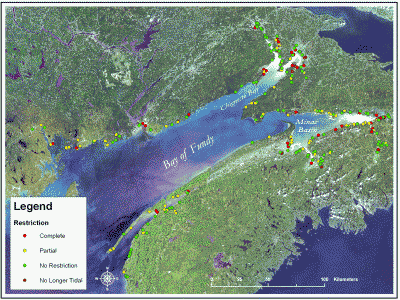 The
purpose of this collaborative research project was to integrate the Bay of Fundy
Tidal Barrier Audits conducted by the Ecology Action Center (EAC) and
Conservation Council of New Brunswick (CCNB) into a comprehensive digital
spatial database being developed in a concurrent project with Environment
Canada. Together, they will be used as a baseline to assess the cumulative
impacts of tidal barriers in the Upper Bay of Fundy and serve as a platform for
future research. This portion of the project will focus on data that is of
particular interest for salt marsh restoration initiatives and serve as a
valuable management tool. Baseline data currently integrated into the database
include: 1:10,000 planimetric (NS,NB), property management units and type
classification (NS), watershed boundaries (NS,NB), digital elevation model (NS,
NB), Landsat 7 ETM - 30 m resolution imagery as well as digital orthophographs
(4m resolution) for New Brunswick (NB) and orthorectified aerial photographs (1
m resolution) for portions of Nova Scotia (NS), particularly the Southern Bight
of the Minas Basin. The full GIS is available to researchers and government
agencies as long as the potential users have secured appropriate licensing
permission from the data providers if those data are not freely available. The
geographical coordinates of tidal barriers inventoried for both NS (216 sites)
and NB (91 sites) have been integrated into the GIS. Full fact sheets and
summaries of the audits were prepared in conjunction with the EAC for NS and are
available on-line as downloadable PDFs. Basic attribute information and maps
for NB barriers will also be available within the GIS framework however
completion of complete fact sheets available to the public is not feasible
within the time frame of the project at this time. LINK
to TIDAL BARRIER DATABASE via B0FEP website.
The
purpose of this collaborative research project was to integrate the Bay of Fundy
Tidal Barrier Audits conducted by the Ecology Action Center (EAC) and
Conservation Council of New Brunswick (CCNB) into a comprehensive digital
spatial database being developed in a concurrent project with Environment
Canada. Together, they will be used as a baseline to assess the cumulative
impacts of tidal barriers in the Upper Bay of Fundy and serve as a platform for
future research. This portion of the project will focus on data that is of
particular interest for salt marsh restoration initiatives and serve as a
valuable management tool. Baseline data currently integrated into the database
include: 1:10,000 planimetric (NS,NB), property management units and type
classification (NS), watershed boundaries (NS,NB), digital elevation model (NS,
NB), Landsat 7 ETM - 30 m resolution imagery as well as digital orthophographs
(4m resolution) for New Brunswick (NB) and orthorectified aerial photographs (1
m resolution) for portions of Nova Scotia (NS), particularly the Southern Bight
of the Minas Basin. The full GIS is available to researchers and government
agencies as long as the potential users have secured appropriate licensing
permission from the data providers if those data are not freely available. The
geographical coordinates of tidal barriers inventoried for both NS (216 sites)
and NB (91 sites) have been integrated into the GIS. Full fact sheets and
summaries of the audits were prepared in conjunction with the EAC for NS and are
available on-line as downloadable PDFs. Basic attribute information and maps
for NB barriers will also be available within the GIS framework however
completion of complete fact sheets available to the public is not feasible
within the time frame of the project at this time. LINK
to TIDAL BARRIER DATABASE via B0FEP website.
Collaborators:
-
Environment Canada
Atlantic Region
-
Ecology Action Centre
-
Conservation Council of
New Brunswick
-
Salt Marsh and
Restricted Tidal Systems (SMARTS) BoFEP working group
Funding Sources:
-
Funding for this portion was obtained through a contribution agreement
between the Gulf of Maine Council on the Marine Environment and the
Bay of Fundy Ecosystem Partnership with support from the National Oceanic
and Atmospheric Administration (NOAA) (contract # NA040AR4600075)
-
Environment Canada Atlantic Region